Department Urban Water Management
BGB Living Lab Bern
What is it about?
The Reallabor Bern Viererfeld/ Mittelfeld monitors the effects of urbanization on various environmental factors, such as water balance, heat balance or biodiversity. Various scientific projects will have the opportunity to gain valuable insights and unique basic data.
In central Bern, a 20 ha greenfield site (Viererfeld/Mittelfeld) will be developed to house 3’000 people. This narrow window of opportunity to capture the ‘pre-development’ state before and during construction will yield rare data of scientific merit and immense value for our Blue Green Infrastructure and Biodiversity (BGI/BGB) research.
With an initial set of sensors, we will capture baseline hydrological and microclimate conditions. Ultimately, we wish to establish an urban living lab for BGI/BGB research that leverages rich longitudinal measurements of this urban transformation. We are currently creating a consortium of researchers interested in the urban living lab idea, including scientists at Eawag, WSL and the University of Bern, in the fields of biodiversity, noise & light pollution, urban soils, hydrogeology, heat research and citizen science. Investments in this project will produce a unique and rare data set with its own scientific merits, of significant value to our BGI research and for publication.
This project contributes to the Blue Green Biodiversity research initiative - an Eawag-WSL collaboration focusing on biodiversity at the interface of aquatic and terrestrial ecosystems.
The second phase of the Blue Green Biodiversity Research Initiative has ceased end of 2024 and therefore also this project came to an end.
About the Viererfeld/Mittelfeld development project
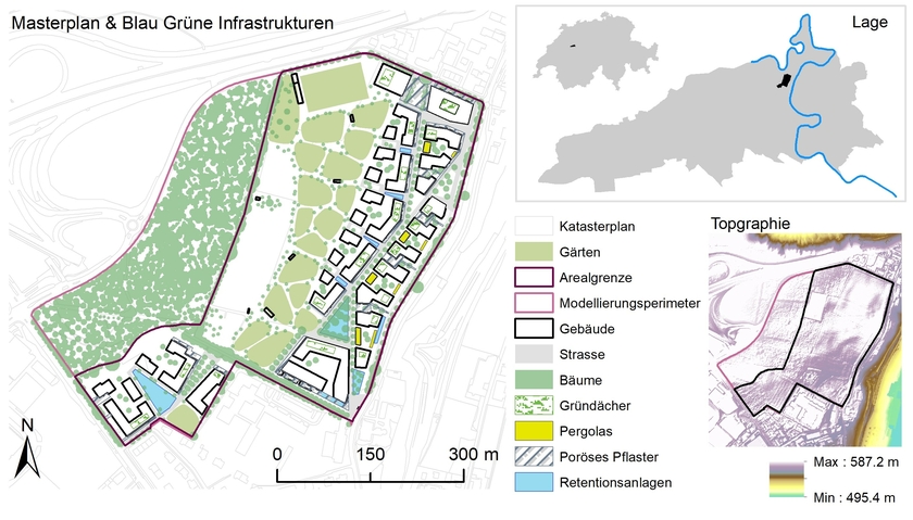
The Viererfeld/Mittelfeld neighborhood aims to provide a natural and well-connected living environment. Importance is placed on the use of native and site-specific plants. Facades and green roofs are encouraged, while sealed surfaces are kept to a minimum. Blue-green infrastructure will be implemented to mitigate the effects of urbanization and restore the water and energy balance to a more natural state. Climate-adapted design will ensure a high quality of life in the future. One example of the ecological approach can be seen in the versatile design of roof landscapes that will benefit both humans and insects. The roofs will also serve as rainwater retention areas, for energy production, and hot water.
More about the neighborhood planning can be found here: City of Bern Viererfeld/Mittelfeld: Stadt Bern Viererfeld/Mittelfeld
BGI - Blue Green Infrastructure
Blue Green Infrastructure is a strategically planned network of natural and semi-natural areas that are designed and managed to provide a wide range of ecosystem services. A few examples of green elements are: Hedgerows, shrubs, and roof gardens. Some examples of blue elements are: ponds, pools, and man-made buffer ponds. BGI's are intended to limit the impacts of urbanization and help restore the water and energy balance to a more natural state. In the context of climate change (heavy rain events, heat waves, floodings etc.), BGI will become increasingly important in urban planning.


How do we get there?
Eawag, in collaboration with WSL and the University of Bern, is creating an Urban Living Lab in Bern. An Urban Living Lab is a public space that allows a wide range of stakeholders and citizens to work together to develop innovative urban services in a real-world setting. This will also provide an infrastructure for other research groups to participate with their own monitoring projects. Participants include scientists from the fields of biodiversity, noise and light pollution, urban soils, hydrogeology, Heat research and citizen science. The project life cycle is characterized by four stages:
- Establishing a baseline before urbanization: Installing a sensor network to establish a baseline data set before urbanization begins. The data will focus on water and energy budget monitoring.
- Tracking of construction-related changes: Record initial environmental changes during the urbanization phase and determine the impact of BGI on water runoff, flooding, and environmental heat.
- Post-construction assessment: Post construction analysis to determine whether BGI can reduce the impacts of urbanization of a new residential area to pre-urbanization levels.
- Project completion: End of active research phase.
Establishing the baseline situation before urbanization
The first phase consists of four main tasks:
- Building baseline models
- Sensor network design and refinement
- Installation of sensors and hardware
- Data and software integration
To better understand the initial situation in the Vierer-, Mittelfeld and to estimate the effects of the development and planned BGI, various models were created. Three scenarios were considered in each case:
- before the development
- after the development, excluding BGI
- after the development, including BGI
It often takes several years for the full effects of the BGI to unfold, as the vegetation must first establish itself. In order to obtain the most comprehensive picture of the scenarios, the focus of the modeling work was placed on several perspectives. Models were created for the topics of biodiversity, heat, and flooding. The modeling results can be seen in the figure below.
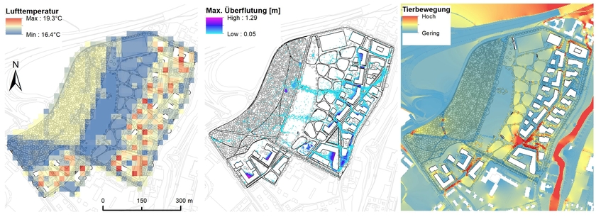
It is expected that the urbanization of the area will have negative impacts, but these can be significantly mitigated by the targeted use of the planned BGI strategy. In comparison with the current agricultural areas, the planned BGIs can promote biodiversity and increase animal movement. The hydrological impact of the BGIs shows a significant step towards the renaturalization of the water cycle with little impact on waterways and existing infrastructure. The most significant role is played by the planned water cisterns in the area as a key point for several ecosystem services.
For building up the sensor network we rely heavily on technology and experience from the Urban Water Observatory (UWO) in Fehraltorf. For most sensors, we will use the low-power data transmission protocol LoRaWAN.
Figure 3 shows the weather station already installed in the Viererfeld. The data from the weather station can be viewed at the following link: Eawag - Eawag - Reallabor Viererfeld (sensors-eawag.ch). Over the next few years, a refinement of the sensor network will take place.

What are the advantages of the project?
The Urban Living Lab Bern will serve as a showcase project for Blue-Green climate change adaptation measures in Switzerland. It will bring together different interdisciplinary research projects on one site. This creates the unique possibility of a holistic approach to BGI's, which is currently still lacking in research. Until now it was hard to quantify the impact of BGI’s due to missing baseline data. This project will change this! We have the great opportunity to observe the energy and water balance during the whole life cycle of the urbanization project. Investment in this project will produce a unique and rare dataset with its own scientific merits that will be of great value to our BGI research and publications.
Note
The open character of the real-world laboratory enables the research consortium to integrate new members at any time. If you are interested in the research project and would like to contribute with your expertise, you are welcome to do so. Please feel free to contact us without obligation.
The extended project team consists of researchers from Eawag, WSL and the University of Bern. There is collaboration with the city of Bern (Bern Civil Engineering Department, Bern City Green Space Department, Bern City Property Department).
| | |


