Department Urban Water Management
floodTANA
A pluvial flood risk assessment framework for the evaluation of large-size blue-green infrastructures (bgis) in data-scarce, peri-urban regions.

Motivation
Pluvial floods have, in recent years, become a significant threat to the economic, environmental, and social assets in many areas globally. The impacts of these events have magnified due to anthropogenic and natural causes. Despite this, pluvial flooding has been neglected in research and practice. Especially in data-scarce peri-urban regions, historical records of the physical properties of pluvial floods are generally lacking due to the high spatial and temporal resolution data required to capture the dynamics of this type of floods, while damage data are also often unavailable for these regions due to their low insurance coverage and informal approaches to urban water management. Therefore, methods to assess and manage pluvial floods are usually unavailable, or are not specific to inform decision-makers in these contexts.
There are new opportunities to manage pluvial floods while providing additional co-benefits – these are so called Blue Green Infrastructures (BGIs). However, research on their application in data-scarce peri-urban regions is limited. Large-size BGIs include rice fields, wetlands, ponds, and forests, which are not feasible to implement in fully urbanized areas. These infrastructures have the potential to provide catchment-wide flood risk reduction even under extreme events and can affect the water cycle to a great extent. However, as most of the research regarding BGIs has been carried out in urbanized areas, large-size BGIs have been less explored in research with respect to their optimal location, modelling, and evaluation.
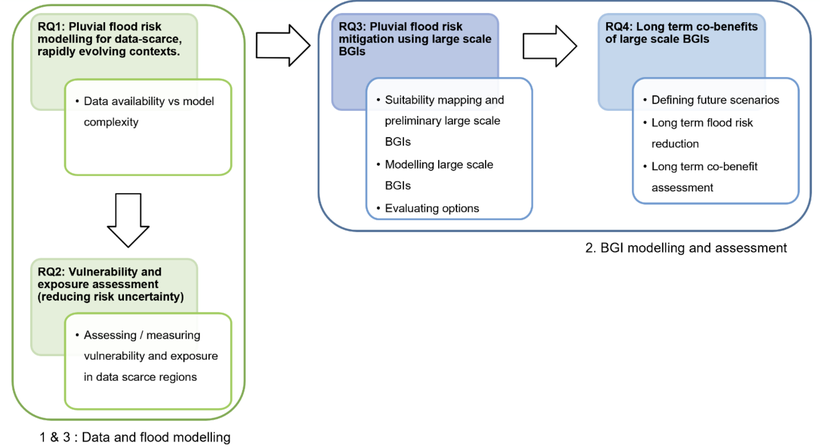
Research Areas
Challenges and research gaps were identified in two main research areas: (1) the assessment of pluvial flood risk in data-scarce, rapidly evolving, peri-urban areas, and (2) the design, modeling, and assessment of large-size BGIs to mitigate floods in these regions. This project will explore both of these areas and provide a methodology to dynamically evaluate the potential of large-size BGIs to mitigate pluvial flood risk and provide additional co-benefits in data-scarce, peri-urban regions. An overview of the research areas and questions is given in Figure 1. The methods developed in the research will be tested on a case study in Antananarivo, Madagascar, but will be applicable to all data-scarce, rapidly evolving peri-urban areas.